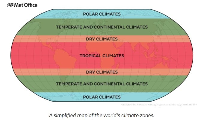
The Köppen system divides climates into five groups. This is a simplified map of the World’s climate zones.
This 2nd map takes account of the factors that affect climate that we looked at in Small World (p102, 103):
Latitude, aspect, altitude, prevailing winds, distance from the sea, ocean currents.

A: Tropical or equatorial zone (represented by blue ). Close to the equator and have high temperatures and rainfall.
B: Arid/dry zone (represented by red, pink, and orange). North and south of the tropical zone.
C: Warm/mild temperate zone (represented by green).
D: Continental zone (represented by purple, violet, and light blue).
E: Polar zone (represented by grey). Only in the Arctic and Antarctic regions
These 5 zones are further subdivided into
- Tropical climates
- Wet (rainforest)
- Monsoon
- Wet and dry (savanna)
- Dry climates
- Arid
- Semi-arid
- Temperate climates
- Mediterranean
- Humid subtropical
- Marine
- Continental climates
- Warm summer
- Cool summer
- Subarctic (boreal)
- Polar climates
- Tundra
- Ice cap
For your climate mini-project, choose 1 climate zone.
- Name countries with this climate in the Northern and Southern Hemispheres or show them on a map.
- Describe characteristics of this climate, eg temperature, precipitation, seasons
- List vegetation (plants/crops) and types of animals common to that climate. Describe ways that these living things are adapted well to their environment.
- Describe or draw how humans have adapted to this climate. Mention clothing, housing/shelter, transport)
These are useful websites. If you find any others helpful websites or books, do include them in your bibliography. https://www.climatetypesforkids.com/
https://www.metoffice.gov.uk/weather/climate/climate-explained/climate-zones